The Amazing Aerial Photography of Georg Gerster
To me, photography is the simultaneous recognition, in a fraction of a second, of the significance of an event.
- Henri Cartier-Bresson
Since 1956 Georg Gerster has been a freelance journalist specializing in science reporting and aerial photography. He has undertaken extensive visits to every part of the world,
including Antarctica. Visit his site for loads more arresting photos. My only complaint is that there is
little detail about each subject - but I suppose there is always Wikipedia...
Camel Caravan in Iran 1976
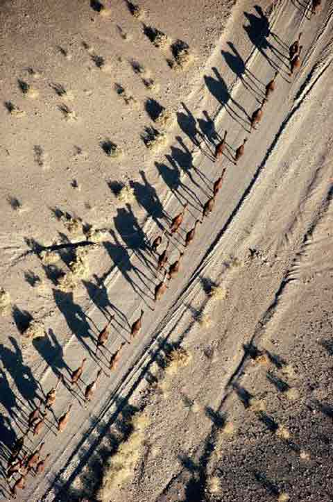
Source: georggerster.com

Village in Tanzania 1984
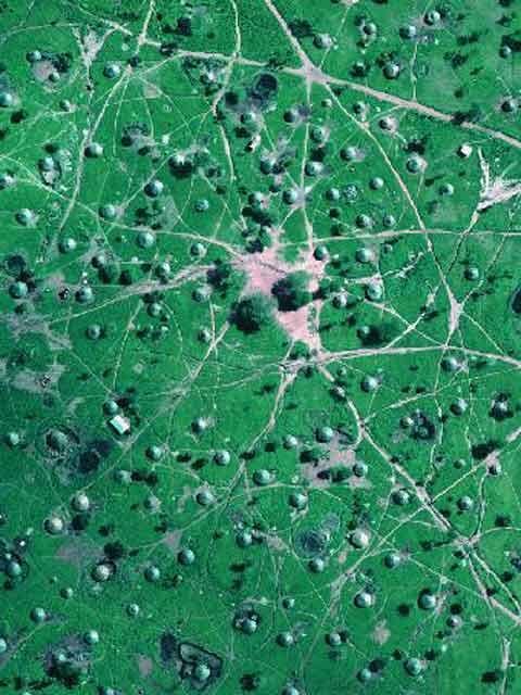
Source: georggerster.com
I like it because it looks like a giant leaf with galls...
Bryce Canyon, Utah 1970
This is karst.
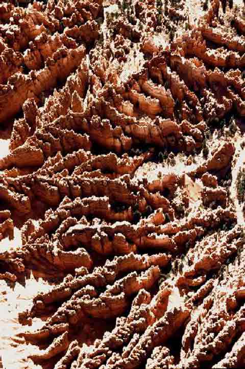
Source: georggerster.com
See also:
 | Logging Threatens Mystical World (In the Environment section) - Underfoot lies another world, even more
ancient: a dark labyrinth of caves and subterranean streams carved through limestone and marble bedrock. Huge sinkholes, pits and vertical crevices called grikes riddle the
forest, channeling water downward, where it may flow for miles before emerging. This landform, characterised by subsurface drainage, is known as karst... |
| Punching a Hole in the Earth (in the Money/Politics "How Many Countries in the World"
section) - Karst is limestone rock eaten away by runoff water which turns into sulfuric acid when combined with the rock, thus forming caves or sinkholes. This sinkhole is
330-feet deep and has swallowed a dozen houses and three people - so far... |
| Madagascar Karst (in the Money/Politics "How Many Countries in the World" section) - This geological
formation, called a karst, is the result of erosion, as acid rains have gradually dissolved the stone of the chalky plateau and carved out sharp ridges that can rise to heights of 95
feet (30 metres). This nearly impenetrable labyrinth (tsingy is the Malagasy term for "walking on tiptoe") shelters its own unique flora and fauna, which have not been completely recorded... |
| The Zacatón Cenote (in the Money/Politics "How Many Countries in the World" section) - Cenotes
are karst formations which occur when underground water etches away at limestone bedrock to form enormous subterranean caverns. Eventually the cavern roofs collapse leaving deep
circular rock pools. The word cenote is a Spanish rendering of the Mayan word d'zonot which means literally "a hole in the ground"... |

For photos of the earth and moon, stained glass, sunsets on the Wellington Harbour, Lady Fair, Civic Square, the old mill, the Whippany River, historical houses, Lake Parsippany and more clicking
the "Up" button below takes you to the Index page for this Photographs section.
|
 Animals
 Animation
 Art of Playing Cards
 Drugs
Drugs Education
 Environment
 Flying
 History
 Humour
 Immigration
 Info/Tech
 Intellectual/Entertaining
 Lifestyles
 Men
Men Money/Politics/Law
 New Jersey
 Odds and Oddities
 Older & Under
 Photography
 Prisons
 Relationships
 Science
 Social/Cultural
 Terrorism
 Wellington
 Working
 Zero Return Investment