Animals
 Animation
 Art of Playing Cards
 Drugs
Drugs Education
 Environment
 Flying
 History
 Humour
 Immigration
 Info/Tech
 Intellectual/Entertaining
 Lifestyles
 Men
Men Money/Politics/Law
 New Jersey
 Odds and Oddities
 Older & Under
 Photography
 Prisons
 Relationships
 Science
 Social/Cultural
 Terrorism
 Wellington
 Working
 Zero Return Investment
Mother Nature Speaks
Survey Nets Volcanic PrizeVolcanoes are one way Earth gives birth to itself. - Robert Gross by Peter Pockley
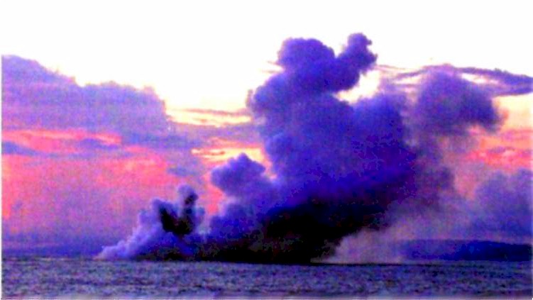
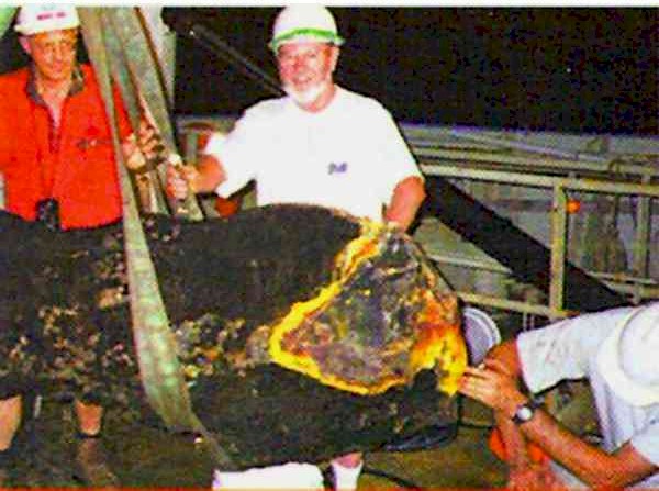
Sydney - The largest volcanic chimney ever to be recovered from the sea floor is being brought ashore by an international team working for the Commonwealth Scientific and Industrial Research Organisation. Caught by the marine research vessel Franklin during an expedition focusing on mineral formation in the Western Pacific Ocean, the chimney is 2.7 metres high, 70 - 80 cm across and weighs one tonne. It was snagged by a dredging net during a routine survey of the Eastern Manus Basin in the Bismarck Sea. The research team witnessed remarkable island-building activity as the marine volcano Kavachi erupted for the first time in 9 years. Kavachi, near the Solomon Islands, produced eruptions 800 metres high every five minutes, ejecting ash and incandescent blocks of lava up to 70 metres above sea levels.
Source: Nature Vol 405 1 June 2000
The Greatest Explosionby Nigel Bunce and Jim Hunt Directly south of Borneo is an arc of islands extending from Sumatra in the West to Timor in the east with Java in the middle. To the east of Java is a much smaller island called Sumbawa and on its northern coast is the Sanggar Peninsula. Most of this peninsula is occupied by Mount Tambora, a volcano, which produced the greatest explosion in recorded history. There is a popular belief that Krakatoa, off western Java, produced the greatest volcanic explosion in 1883, but Tambora in 1815 exceeded it by at least a factor of ten. Tambora had been believed to be extinct but it started rumbling about 3 years prior to a small eruption on 5 April 1815. Eruptions continued up to 10 April and could be heard 1,200 km away on Java where ash started to fall. At 7:00pm on 10 April the eruptions reached a cataclysm. Observers reported 3 columns of fire which rose to a great height and the whole mountain appeared like a flowing mass of liquid fire. Pumice stones fell on the village of Tambora at 8:00pm and ash an hour later. The explosion created violent winds which uprooted trees and overturned houses. At l0:00pm the mountain collapsed. Eruptions and explosions continued into 11 April. So much ash was injected into the atmosphere that localities within 600 km of Tambora remained dark for up to 2 days. Enormous rafts of pumice several kilometers across and a metre thick were left floating on the sea. When the smoke cleared, Tambora was less that two-thirds of its original height. In a recent article in Science, Richard Stothers of NASA has reviewed the Tambora event and studied its aftermath. A particularly interesting question is how much of the mountain was injected into the atmosphere and whether or not the explosion "punched through" to the stratosphere. The event was rather thoroughly studied by naturalists of the time, and using their measures of ash depth at various locations, Stothers has calculated that 40 to 90 cubic kilometers of material was injected into the atmosphere and fell out over the next week in a circular area about 400 km in diameter. There is strong evidence that some of the dust and aerosols reached the stratosphere and were dispersed around the world by high level winds. Between 28 June and 2 July and later in September, brilliant sunsets and twilights were seen in London. In the following year a persistent "dry fog" was reported in the northeastern United States and the sun was so dimmed that sunspots could be seen with the naked eye. The year 1816 was known to Europeans and North Americans as "the year without a summer." There was much snow and frost in New England and Canada and rain in Western Europe. Many crops failed and there was much famine and disease, exacerbated by the end of the Napoleonic wars. Many meteorologists believe that this uncharacteristic weather was caused by Tambora's obscuring dust veil. Krakatoa in 1883 deposited less than half of Tambora's dust in the atmosphere and had no perceptible effect on the weather. Studies of events like Tambora are taking on a new importance as they are models of certain aspects of nuclear explosions. By extrapolating from such studies, scientists can attempt to predict the sequence of events in a nuclear war and warn us in advance about the "nuclear winter" and other such phenomena. College of Physical Science Source: physics.uoguelph.caScience Corner 28 September 1984
Scientists Striving to Better Predict Eruptions
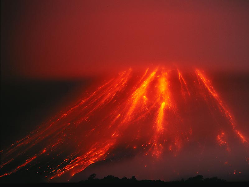
Soufriere Hills by Tim Friend As the Soufriere Hills volcano continues to decimate the tiny Caribbean island of Montserrat, there are 1,500 others throughout the world that have the potential to awaken one day and wreak havoc. Currently, scientists adequately monitor only 20 volcanoes and have the resources to occasionally observe just a third of the 500 slumbering giants that have a record of violent behaviour. Unfortunately, volcanoes pose an increasing risk to the world population, and they deserve a lot more attention than they are getting, says John Ewert, a volcanologist with the US Geological Survey's (USGS) Cascades Volcano Observatory, Vancouver, Washington. "The biggest reason volcanoes are worth watching is that they have been with this planet since it was formed, and they are not going to go away," Ewert says. "Meanwhile, volcanoes are becoming more of a problem every year because human populations are growing and encroaching on the areas where volcanoes are located. If history tells us anything, even a tiny eruption in a populated area can have devastating and far-reaching effects." Since 1980, volcanoes have killed more than 30,000 people world-wide and forced the evacuation of 1 million people from their homes. On 13 November 1985, a small eruption on the snow-covered peak at Nevada del Ruiz in Columbia, South America, created a lehar, which is a raging river of ash, mud and rock. It killed 23,000 people. According to the USGS, 50 volcanoes awaken every year, and 10 of those, like Soufriere Hills, will cause significant damage. Highly disastrous eruptions, such as Mount Pinatubo, may occur once or twice each century, and eruptions like Mount St Helens occur two to four times every decade. Volcanoes also pose a risk to passengers on jumbo jets that travel near recent or ongoing eruptions. Experts are attempting to monitor ash clouds from belching volcanoes, which have flamed out the engines of jumbo airliners on more than five occasions. Ash clouds are difficult to discern from ordinary clouds. They pose a threat to the 10,000 passengers a day who fly North Pacific air routes, including airspace over Washington, Oregon and Alaska and between the Western US and Japan and Australia. Volcanoes have cost the world economy billions of dollars in damage since 1980 and can significantly affect global climate, says Ewert, who is part of the world's only volcano emergency response team, established in 1986 by the USGS and Office of Foreign Disaster Assistance after Ruiz. Two years ago, the mobile unit set up the first monitoring station at Soufriere Hills with a team from the West Indies and was the first to warn of the volcano's impending danger. The team also monitored and predicted the explosion at Mount Pinatubo in the Philippines in 1991. Most members are veterans of the 1980 eruption of Mount St Helens in Washington and know too well how an explosive one can destroy communities in an instant and in some cases kill tens of thousands of people. Of greatest concern are volcanoes that lie dormant for centuries or even thousands of years and then awaken with little warning, says Rick Hoblitt, also of the USGS team. During the escalating activity prior to Pinatubo's eruption, Hoblitt made daily helicopter trips over its smouldering vents and maintained a meticulous field diary that was used in the PBS documentary In the Path of a Killer Volcano. Pinatubo lay quiet for 600 years before erupting in 1991, and few people there even realised it was a volcano. Soufriere Hills at Montserrat slept for nearly 400 years. The challenge for volcanologists is to spot these volcanoes when they first yawn, then monitor their activity and predict whether and when they will become violent. The USGS team, which is led by Dan Miller and also includes Andy Lockhart, Jeff Marso and Marvin Couchman, builds many of its own instruments for measuring different types of volcanic activity. Measurements are becoming much more sophisticated, but they always include seismicity, gases and deformation of the ground. Generally, the first signs of volcanic activity are swarms or clusters of dozens to hundreds of earthquakes that come from deep inside the volcano. Earthquakes occur as magma and gas force their way up from the Earth's crust through fractures or conduits beneath the volcano. When the pressure causes rock to break, high frequency earthquakes will be recorded by seismic monitors positioned around and sometimes in the volcano. If the pressure is causing existing fractures to vibrate, continuous shaking called a volcanic tremor is triggered. "A tremor usually indicates that fluid is in motion and could be rising, which is important to know," Ewert says. The driving force behind a volcano is gases in the magma. When magma rises slowly, gases can escape and the magma becomes less explosive. For most of Soufriere Hills awakening, the magma has been nonexplosive, and that has allowed domes to build slowly at the summit. As the domes grow higher, they collapse under gravity and fall down the mountainside as a pyroclastic flow, which is an avalanche of glowing hot ash. The molten ash of a volcano is like dry, ready-mix cement. But on several occasions , magma was exposed to the surface before the gas could escape and exploded. When that happens, a giant cloud of ash is ejected into the sky, as it was at Pinatubo, and pyroclastic flows become terrifying forces of nature. At Mount St Helens, the lava and gas exploded through the side of the mountain with such force that the pyroclastic flow flattened trees that were six feet in diameter and 15 miles away. On some occasions before an explosion occurs, scientists can detect sulphur dioxide, which also is escaping as a gas from the magma. Escaping sulphur suggests that magma is rising and close to the surface. If scientists could monitor dormant volcanoes for sulphur emissions, they might be able to predict more of the planet's eruptions, experts say. Scientists also are conducting measurements of carbon dioxide as a potentially more important warning sign of rising magma. Today, these measurements are made primarily with ground-based instruments after seismic disturbances have alerted experts to trouble. While these measurements will always be critical, there simply aren't enough scientists or instruments to monitor all the world's volcanoes. That's where satellite-based observations could make a difference, says NASA scientist Arlin Krueger at the Goddard Space Flight Centre, Greenbelt, MD. He designed an instrument called the Total Ozone Mapping Spectrometer (TOMS), which has been used on satellites to measure ozone since 1978. But TOMS also can easily measure sulphur dioxide. So far, orbiting instruments have not had the sensitivity to detect small emissions. But TOMS made it possible to track large sulphur emissions globally after an eruption, which is important for climate forecasting. The National Oceanographic and Atmospheric Administration monitors sulphur emissions with satellites and can locate newly erupted volcanoes within 12 hours. Scientists at the Alaska Volcano Observatory and National Weather Service are using TOMS to detect eruptions so that aircraft can be re-routed around ash clouds. Krueger says with the right instrumentation and satellite, sulphur gases could be detected as they're occurring before an eruption. "My campaign is to look at every volcano every 15 minutes," he says. "But it is hard to get people's attention." A satellite is being launched by NASA in 1998 that is expected to enhance the ability to monitor volcanoes from space. The Earth Observation System (EOS) AM1 Platform will carry an instrument called the Moderate-Resolution Imaging Spectroradiometer. "We will be able to make infrared and radar observations, which can see through clouds and work day or night to monitor changes on the volcano before they become explosive," says Pete Mouginis-Mark, director of the NASA EOS Volcanology Team at the University of Hawaii. The most unpredictable and dramatic volcano is the stratovolcano, or composite volcano. Mount St Helens and Mount Rainier in Washington, Mount Fuji in Japan, Mount Cotopaxi in Ecuador, Mount Shasta in California and Mount Hood in Oregon are all stratovolcanoes, as is Soufriere Hills. Volcanoes in Hawaii are different because they form from spreading lava and build up broad, gently sloping sides. The stratovolcano is steep-sided and built of alternating layers of lava flows, volcanic ash, cinders and other volcanic materials. The major threats from stratovolcanoes are pyroclastic flows, which can reach temperatures up to 1,500 degrees F and speeds up to 500 miles per hour; lehars, which look like fast moving rivers of liquid concrete; and tephra columns, or ash clouds. Pyroclastic flows have been the major destructor at Montserrat. Since the first recent eruption on July 18, 1995, which was a sudden explosion that released mostly steam and a little ash, the peak of Soufriere Hills has grown from 3,000 feet to 3,185 feet due to the accumulation of the very thick lava. Scientists say the dome is growing at its fastest rate since 1995. But no one can predict whether the volcano will simply turn itself off and lie dormant again for hundreds of years or whether it will become more violent. "We don't know exactly. It's possible we've passed the peak and it is on the downhill slide," Hoblitt says. "However, there has been a slow but regular escalation in activity there. As the rate at which magma is being delivered to the surface increases, you increase the risk of explosive behaviour." But while Soufriere Hills captures the world's attention at the moment, several other hot spots are under careful scrutiny. Among the most active and potentially threatening are Popocatepetl volcano near Mexico City, Kilauea on the island of Hawaii, Rabaul caldera at Papua, New Guinea, Long Valley caldera (195 miles east of San Francisco), Okmok caldera on Alaska's Umnak Island and Pavlof volcano near King Cove, Alaska. Popocatepetl ejected an ash plume on June 30 that caused a 14-hour shutdown of the Mexico City airport. The volcano is within eyesight of 30 million people and is closely surrounded by a population of 750,000. On April 30, 1996, an explosion erupted from the volcano's lava dome and killed five climbers - the only casualties recorded so far. "The story of Popocatepetl started 23,000 years ago," says Servando De la Cruz-Reyna of Mexico's National Disaster Prevention Centre (CENEPRED). "The current episode began in 1993 with seismic activity which increased in 1994. By end of that year the volcano started throwing ash for the first time in about 70 years. That produces significant concern." After the swarm of earthquakes occurred on the mountain, CENEPRED requested the assistance of the USGS mobile response unit, which helped establish a monitoring station. But Mexican scientists are remaining optimistic about the volcano, which destroyed Aztec villages in 800 AD. "The last large eruption occurred about 1,200 years ago," De la Cruz-Reyna says. "There is evidence that it certainly affected towns around the volcano, but the statistics tell us the most likely scenario today is that this current level of activity might continue for several years with no significant consequences." Or not. Source: USA Today 26 August 1997
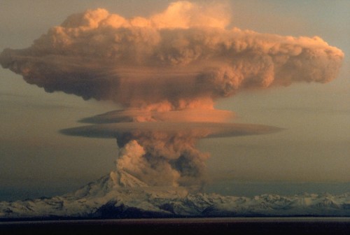
Alaska's Mount Redoubt Erupting
Photo by J Warren, April 1990 Source: themudflats.net
For pages on several other types of natural disasters - including lightning strikes, tornados, hurricanes, floods, global warming and more - as well as some great satellite and tree
photos, clicking the "Up" button immediately below takes you to the Table of Contents page for this Environment section. |