Animals
 Animation
 Art of Playing Cards
 Drugs
Drugs Education
 Environment
 Flying
 History
 Humour
 Immigration
 Info/Tech
 Intellectual/Entertaining
 Lifestyles
 Men
Men Money/Politics/Law
 New Jersey
 Odds and Oddities
 Older & Under
 Photography
 Prisons
 Relationships
 Science
 Social/Cultural
 Terrorism
 Wellington
 Working
 Zero Return Investment
Whirlwind Tour of Miami
Miami's Unwelcome VisitorTo really ask is to open the door to the whirlwind. The answer may annihilate the question and the questioner. - Anne Rice
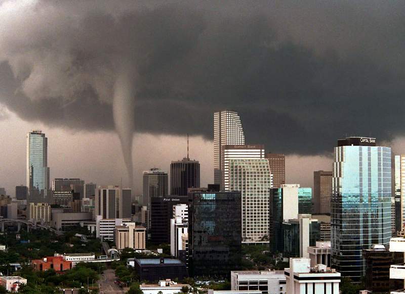
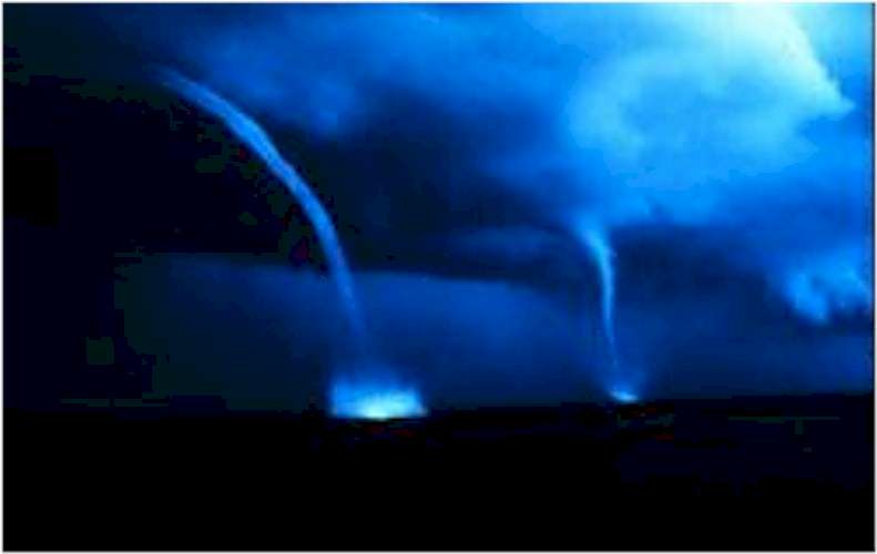
Tornado moving through downtown Miami On 12 May 1997 an F1 tornado moved through the downtown Miami around 2:00pm EDT. Even though the tornado produced significant damage, it will be remembered not for that but for the photographs and videos taken as it moved through the skyscrapers of downtown Miami. The images made newscasts and headlines around the world. Using the latest computer and radar technology the tornado event was well forecast at least 24 hours in advance by the National Weather Service Forecast Office in Miami.
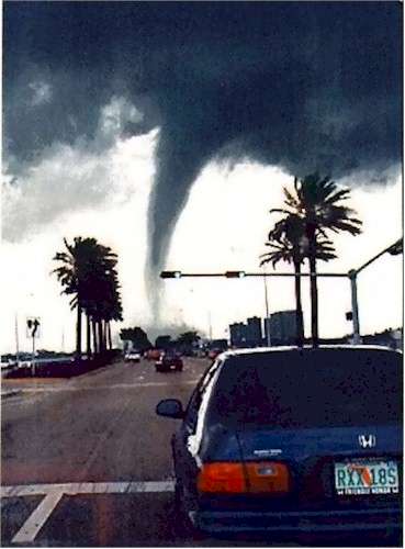
View of tornado moving into Biscayne Bay; Typically, tornadoes in South Florida are generally weak and short-lived. This tornado was a strong F1 on the Fujita Scale which lasted about 15 minutes and affected the downtown area of a major metropolitan city. Most severe weather and tornadoes in South Florida occur in pulse type severe thunderstorms along the interaction of sea breeze and other boundaries which can be difficult to forecast more than a few minutes in advance. Since this event was synoptically driven, the conditions which were indeed favorable for producing supercell thunderstorms were well forecast by medium range computer models, the Storm Prediction Center, and the National Weather Service Forecast Office in Miami. Source: National Oceanic and Atmospheric Administration photos from The Miami Herald; photo 2 credit: Kent F Berg
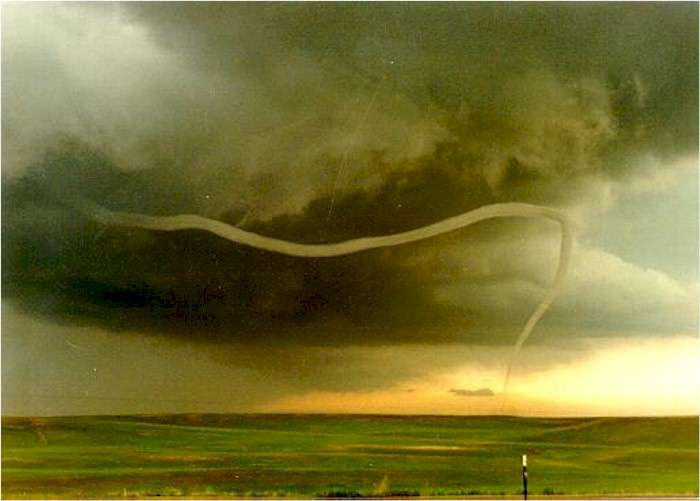
How Tornados Die...by Ian Wittmeyer
Roping out stage of the Cheyenne tornado Source: www.photo.net A source of some stunning photos - I recommend a visit... The photo was taken using a Canon A-1 For more on tornados, see also:
Pretending to Be a Tornado
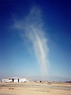
This is a particularly good example of a dust devil with a well developed core. Source: home.earthlink.net This is an unusual site and it's worth clicking on the "Main Page" link at the bottom to see what else is on offer
Whirlwinds and VorticesThe Loch Ness Monster and his other cousins dotted around deep lakes all over the world might be explained by an interesting sort of weather. They could be all mistaken for water devils - small whirlwinds forming over warm waters. They spin up a funnel of water which darts around and looks just like the neck and a head of a dinosaur, often pausing "for breath", and sometimes hissing and bubbling like a frantic animal. No wonder eyewitnesses have been often been scared witless as they've faced one of these "beasts" of the water.
Sea Monsters? No, just waterspouts The same goes for much larger waterspouts over the sea. These are huge vortices of seawater spiralling up into stormy clouds above, and you can see why ancient mariners talked about monsters from the deep. Who knows, they might even explain the mystery of the Marie Celeste's vanished crew, perhaps so terrified by the sight of a sea monster they jumped overboard.
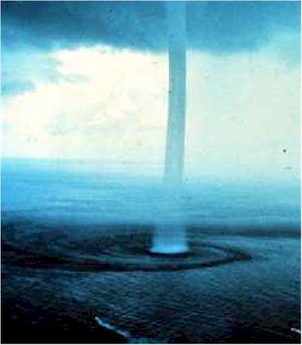
Waterspout in the Bahamas Today, we're more intrigued by crop circles and although most of these are clearly hoaxes, some may be caused by freak weather. One theory is that small, gently spinning vortices can form in the lee of hills and it's quite possible that when they break down they could make flatten crops into circles, particularly on sloping fields. In fact, old woodcuts show crop circles formed by the devil, so these aren't a modern phenomenon by any means. Source: www.firstscience.com photo credit NOAA
And in Another Part of the World...The Power of a Deadly Typhoon
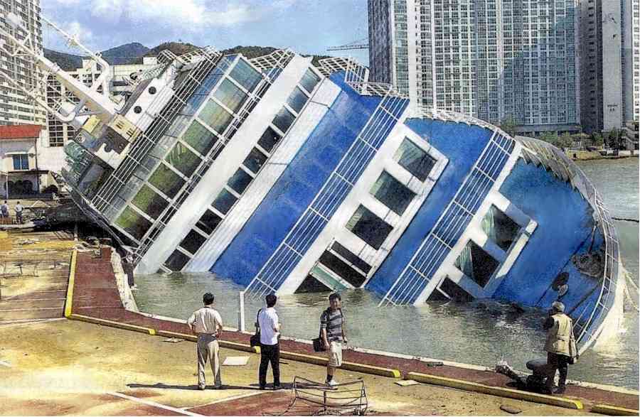
The skies are blue again in Busan, the chief port of South Korea, but the Ferris Flotel, a cruise ship converted into a hotel, provides a reminder of the force of typhoon Maemi, which punished the Korean coast in September, claiming dozens of lives. The hotel had been evacuated before it was knocked over. A hemisphere away, Hurricane Isabel, whose 160 mph winds top even Maemi's, leisurely made its way across the Atlantic in the direction of its landfall - North Carolina. Source: The Sunday Star-Ledger (New Jersey) Sunday 14 September 2003 photo credit Getty Images Also see:
For pages on natural disasters - including lightning strikes, volcanoes and hurricanes but also global warming and more - as well as satellite and castle photos and some great
pictures of trees, clicking the "Up" button immediately below takes you to the Table of Contents page for this Environment section. |