Animals
 Animation
 Art of Playing Cards
 Drugs
Drugs Education
 Environment
 Flying
 History
 Humour
 Immigration
 Info/Tech
 Intellectual/Entertaining
 Lifestyles
 Men
Men Money/Politics/Law
 New Jersey
 Odds and Oddities
 Older & Under
 Photography
 Prisons
 Relationships
 Science
 Social/Cultural
 Terrorism
 Wellington
 Working
 Zero Return Investment
What Plate Crystals Can Do
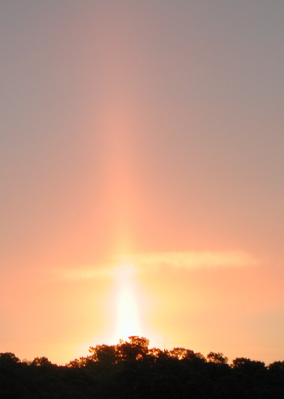
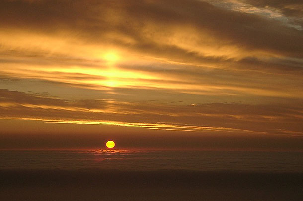
Sun PillarsIn journalistic terms, syndication is equivalent to ascending to heaven on a pillar of cloud. - John Skow Hope is the pillar that holds up the world. - Pliny
Source: wonderquest.com 24 January 2003 Ice crystals form in a wide variety of shapes and sizes: stars, needles, columns and plates. When bright light passes from the sun, moon or an artificial light source through a portion of the sky containing a concentration of ice crystals, magical apparitions often appear. The crystals focus, scatter, bend, split and reflect the light rays into a kaleidoscope of optical phenomena: arcs, glories, halos, pillars and sun dogs. One particularly interesting form is the light pillar. They are most commonly seen as sun pillars; however, moonlight and strong artificial light such as street lamps can also form light pillars. The pillar appears as a feather of light that extends vertically above and/or below the light source. Most sun pillars are seen when the sun is low on the horizon (generally no more than 6 degrees above) or just below it.
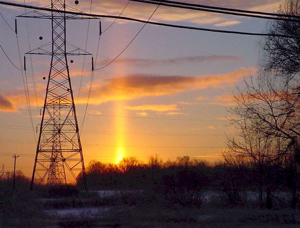
Sun Pillar and Power Pylons taken by Cathy Schultz with a Sony Cybershot Sun pillars usually extend only 5 to 10 degrees of arc directly above the solar disk and are rarely seen as high as 20 degrees above the solar disk. Moon pillars form in the same fashion as sun pillars. Pillars form from artificial lights in a similar manner, but the closeness of the source to the observer can allow larger pillars to form. Pillars appear in the sky when snow or ice crystals reflect light forward from a strong source such as the sun or moon. Those crystals with plate or column shapes provide an excellent surface from which the light may reflect toward the viewer's eyes. Ice crystals in the form of plates or columns can be found in ice clouds (cirrus or alto forms), ice fogs, snow virga falling from high-based clouds, blowing snow and diamond dust. Because the light rays forming pillars are reflected, they take on the colour of the incident light. For example, when the sun is higher in the sky, pillars are white or bright yellow in colour. But when it is near the horizon and its light colour dominantly orange, gold or red, so is the resulting pillar.
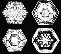
The formation of hexagonal-plate crystals is favoured at air temperatures from 0°C to -4°C (32°F to 25°F) and from -10°C to -20°C (14°F to -4°F). Ice plates resemble dinner plates with a hexagonal pattern in their long dimension and are thin relative to their width (Figure 1 shows some examples of ice plates). When their size is less than 15 - 20 micrometres across, crystal plates tumble randomly through the air as they fall. But when the plates are larger, they fall so that their long dimension parallels the ground, floating downward like descending flying saucers.
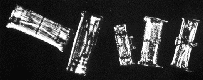
Ice columns resemble stubby pencils rather than the delicate branched snowflake shape our mind conjures up at the first mention of snow. Columns typically form in the temperature ranges -5°C to -8°C (23°F to 18°F) and below -25°C (-13°F). They are long in comparison to their hexagonal cross-section (Figure 2). Larger column crystals also fall with their long axis paralleling the ground. At times, the columns may rotate while falling like slow, miniature helicopter blades.
South American Sun Pillar. Although the sun is setting over the Pacific, waves visible are in the cloud When the larger plates and columns assemble in a stable "flying formation" and strong light passes through the formation from the source to the observer, the ice crystals can act like small mirrors. Pillars appear when the light rays reflect at a grazing angle as they hit the crystal's upper or lower surfaces. Sources: islandnet.com, sundog.clara.co.uk/halo/pillph10.htm, sundog.clara.co.uk/halo/pillar.htm
For more fantastic shots, including rays and shadows, water droplets, rainbows, and ice halos, see sundog.clara.co.uk/atoptics/phenom.htm.
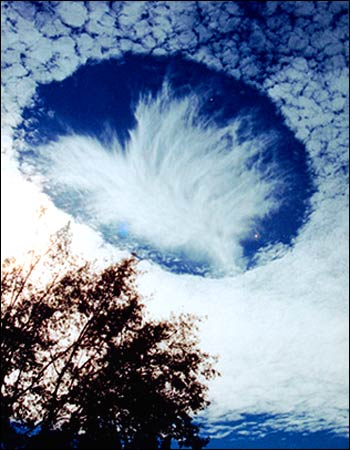
This Isn't a Pillar, but It's Unusual, Interesting and in the Sky...Humans can see only 43% of the sun's light.
"Hole in Sky" Amazes Scientistsby Dr David Whitehouse A giant hole that appeared in a uniform layer of cloud over Mobile, Alabama, in the US, has left scientists puzzled. Local resident Joel Knain said as he took pictures: "I immediately realised that I was seeing something unique." Meteorological experts believe the hole formed when ice-crystals from a passing plane fell through the cloud, causing the water droplets in it to evaporate. Experts say the process involved is related to that of cloud seeding, which is used to make rain over crop fields. The unusual phenomenon was observed on 11 December last year. "I ran inside to get my camera and shot-off 10 - 12 frames to capture the scene," Joel told BBC News Online. "I would guess that we stood there for 10 - 15 minutes just staring in amazement." Strictly speaking there is no scientific term for the apparition, and what exactly it is has been the subject of much meteorological speculation. One hypothesis is that the hole is made by falling ice-crystals that could have come from the exhaust of a passing aircraft. It is possible the air was at just the right temperature and with just the right moisture content so that the falling crystals could absorb water from the air and grow. The moisture removed from the air could have increased the evaporation of the cloud's water droplets, which then disappeared to produce the dramatic hole. The wispy clouds seen below the hole may be heavier ice-crystals that have fallen from the hole, evaporating (the correct term is subliming) before they reach the ground. It's called a fallstreak hole. Dr David Whitehouse is the BBC News Online science editor Source: news.bbc.co.uk Thursday 15 January 2004 Image © Joel Knain
I have seen a sky hole on at least two occasions, so they aren't quite "unique" - unfortunately, I didn't have a camera with me. For reasons that are none too clear, a particular region of supercooled cloud can throw caution to the wind and decide to freeze into ice crystals that grow and fall below leaving a hole behind, and this spreads outwards as neighbouring droplets are swept up in the excitement and start freezing too.
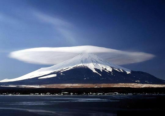
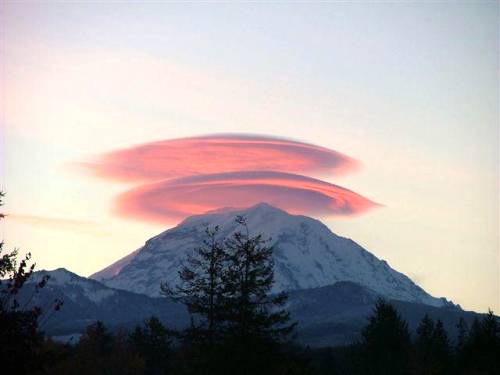
Umbrella(?) Cloud...
West Spanish Peak, South of Walsenburg, Colorado, 20 May 2003 by Mark J Madigan of Colorado Springs, Colorado markjmadigan@yahoo.com The same type of cloud formation over Mt. Rainier in the state of Washington
More Unusual Skies...
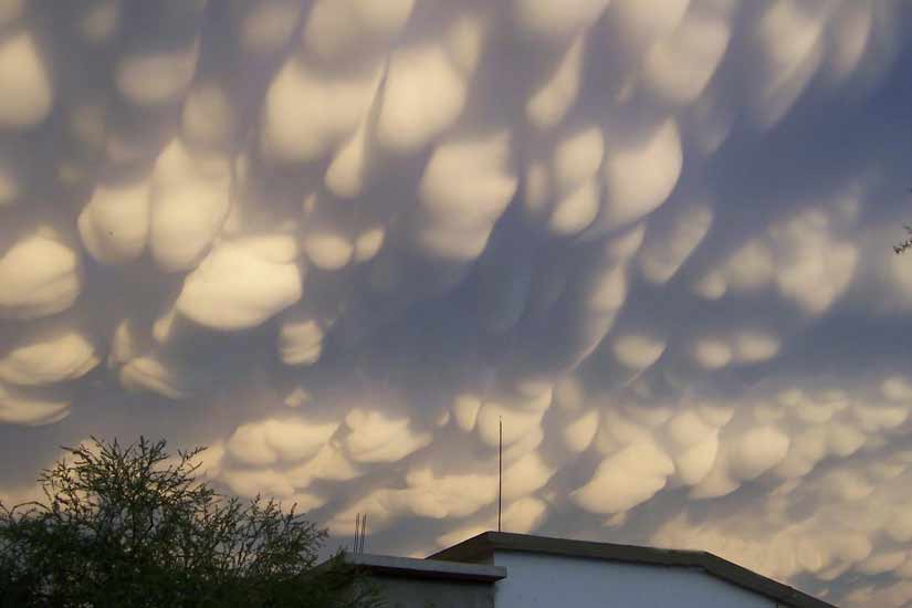
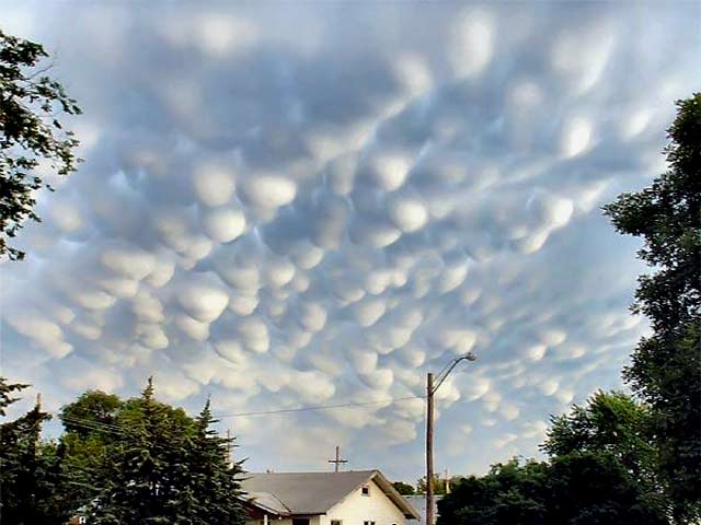
These are cumulus mammatus Source: thesun.co.uk The Sun (UK) sent to them by Cassio Leandro Barbosa
More cumulus mammatus See also:
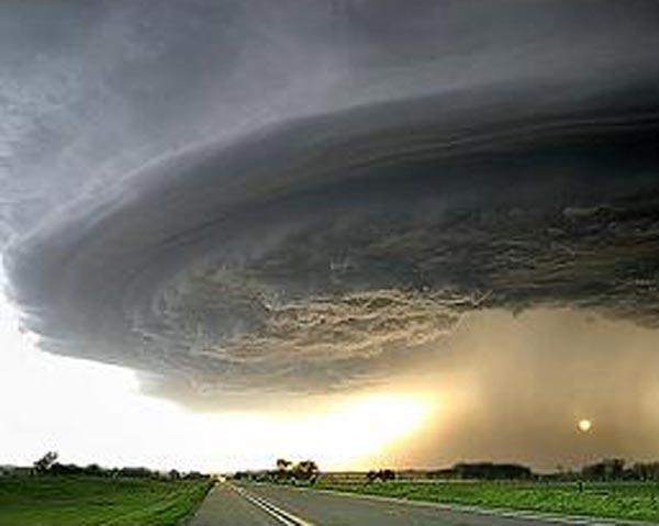
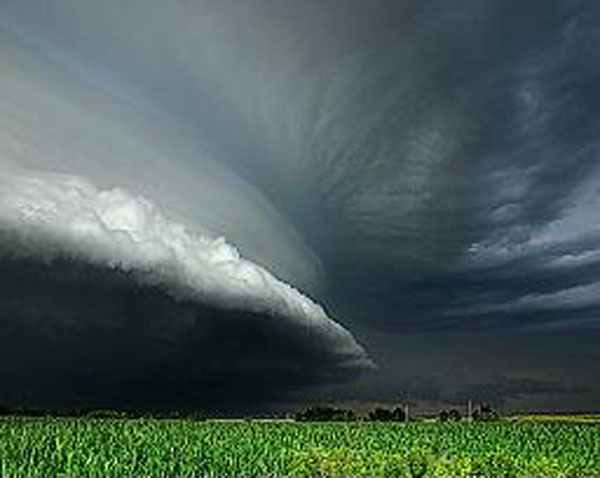
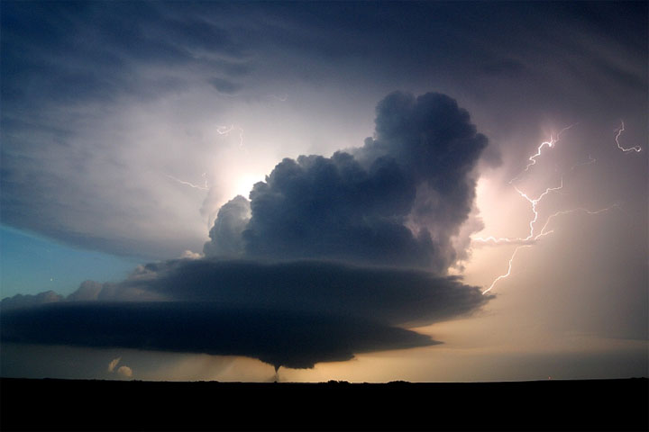
Incredible Storm...
Source: extremeinstability.com The above three photos represent only a small sample. (You can buy quality copies of these magnificent photos there.) I urge you to visit the site - there are videos available there as well.
A huge tornado funnel cloud touches down in Orchard, Iowa, 10 June 2008 at 9:04pm.
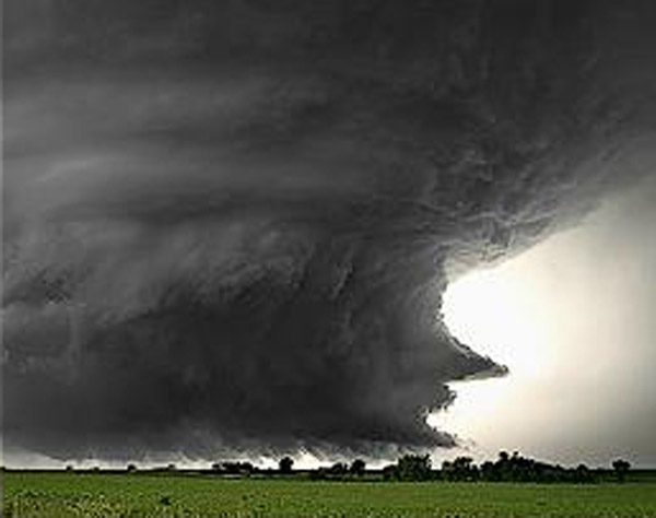
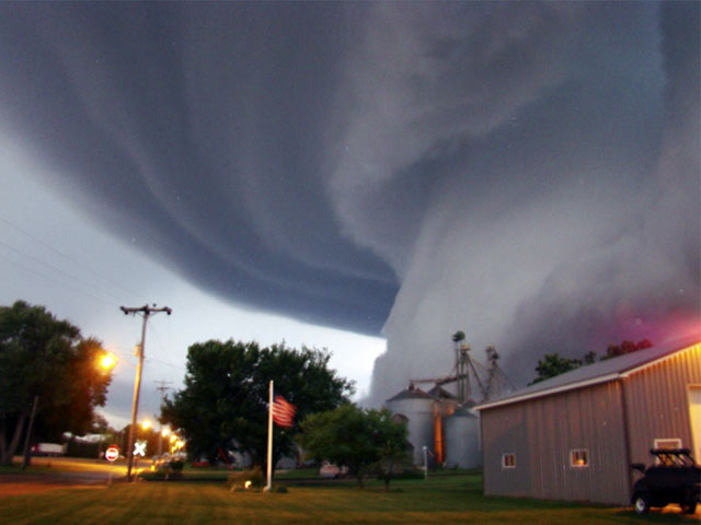
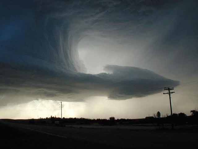
These Formations Are Called a "Shelf Clouds" (the same as the ones above)...
Approaching thunderstorm with lead gust front. Rain-cooled air from the storm moves out ahead of the storm. Source: livescience.com
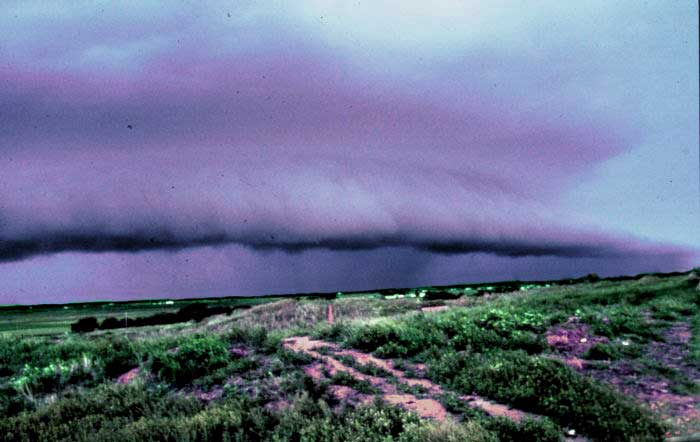
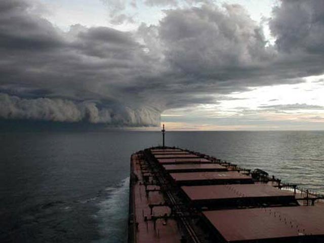
Hurricane? (Awesome, Anyway!)
This is a shelf cloud, typically associated with severe thunderstorms and tornadoes rather than hurricanes; furthermore, the water in the picture appears too smooth for the area of an approaching hurricane. (Even if this image did depict the approach of a hurricane, it is too old to be a photograph of Hurricane Isabel - this picture was circulating as a photographs of Hurricane Claudette in July 2003 and of Cyclone Indigo in April 2003.) Some believe the photograph to have been taken in the midwestern US or Great Lakes region, although at least one source identifies it as being a picture of Tropical Cyclone Graham, which hit northwest Australia in February 2003. Source: snopes.com/photos/isabel.asp
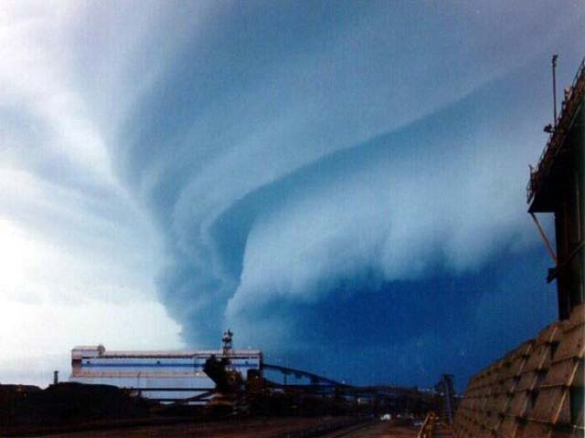
Something for Everyone
Webster County, Nebraska supercell (near Red Cloud) 10 June 2004 via NOAA's National Weather Service Weather Forecast Office Source: crh.noaa.gov by Doug Raflik
Directed Weather
by Avi Abrams Source: flickr.com
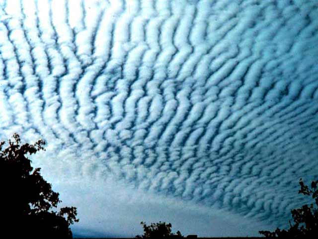
Altocumulus ("Tractor Treads")
Altocumulus clouds in the sky. NOAA Ralph F Kresge Source: livescience.com
For pages on several types of disasters - including lightning strikes, volcanoes, floods, hurricanes, tornados, global warming and more - and also some great satellite photos and pictures of castles
and beautiful trees, clicking the "Up" button immediately below takes you to the Table of Contents page for this Environment section. |