 Animals
 Animation
 Art of Playing Cards
 Drugs
Drugs Education
 Environment
 Flying
 History
 Humour
 Immigration
 Info/Tech
 Intellectual/Entertaining
 Lifestyles
 Men
Men Money/Politics/Law
 New Jersey
 Odds and Oddities
 Older & Under
 Photography
 Prisons
 Relationships
 Science
 Social/Cultural
 Terrorism
 Wellington
 Working
 Zero Return Investment
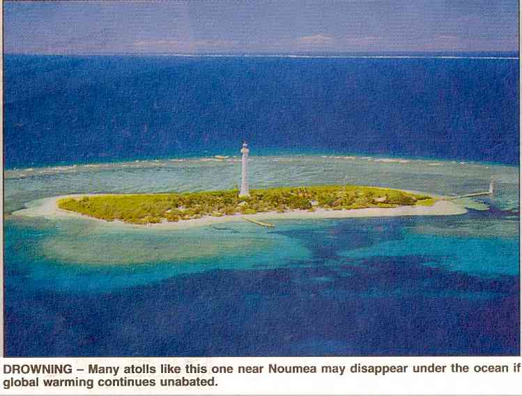
Fronting Up to Rising Seas
Turn Down the Heat! Island Populations under Threat of Rising Sea LevelsIf you asked me to name the three scariest threats facing the human race, - Dave Barry Two islands have disappeared beneath the Pacific Ocean - sunk by global warming. Island leaders say this is just the beginning. The placard said it all. Held high by a small boy in Male, the capital of the Maldives, it carried a simple slogan: "Down with sea level rise." It was 1989 and the boy was making his denunciation (or was it a heartfelt plea?) at a demonstration greeting Ministers from 15 island nations as they gathered to confront a threat to the very existence of their countries.
Scientists were increasingly concluding that global warming was real and that, as the world heated up, the oceans would rise. President Gayoom of the Maldives, who had called the meeting, set the sombre tone. Reminding delegates that, on average, his country's 1,196 islands jut just 3 feet above the waves, he warned: "We are an endangered nation." Ten years on, the gloomy predictions are coming true, faster than anyone expected. Three islands in the Pacific Ocean nation of Kiribati - Tebua, Tarawa and Abanuea - have already disappeared beneath the waves. And others, reports the official South Pacific Regional Environment Programme (Sprep), have almost gone, both in Kiribati and in the neighbouring island nation of Tuvalu. So far the sea has completely engulfed only uninhabited, relatively small islands. But all around the shores of the world's atolls - often described as idylls - the crisis is growing. Populated islands are already suffering. So far this year the main islands of Kiribati, Tuvalu and the Marshall Islands (also in the Pacific) have suffered severe floods as high tides demolished sea walls, bridges and roads and swamped homes and plantations. Almost the entire coastline of the 29 atolls of the Marshall Islands is eroding, reports Sprep. Second World War graves on its main Majuro atoll are being washed away, roads and subsoils have been swept into the sea and the airport has been flooded several times despite being supposedly protected by a high sea wall. The people of Tuvalu are finding it difficult to grow their crops because the rising seas are poisoning the soil with salt. In both Kiribati and the Marshall Islands, says Sprep, families are desperately trying to keep the waves at bay by dumping trucks, cars and other old machinery in the sea and surrounding them with rocks. "Sea level rise is so horrible here the people just don't want to think about it," said Jorelik Tibonn, general manager of the Marshall Islands' national environmental protection agency. "There is nothing they can do to stop it." It is much the same far away in the Maldives in the Indian Ocean. The beaches of 1/3 of its 200 inhabited islands are being swept away. "Sea level rise is not a fashionable scientific hypothesis," says President Gayoom. "It is a fact." The seas are rising partly because global warming is melting glaciers and nibbling away at the polar ice caps, but mainly because the oceans expand as their water gets warmer. Scientists' best estimates are that these processes will raise sea levels by about half a metre over the next century, not apparently a large amount but quite enough to damn several island nations. The higher the seas rise, the more often storms will sweep the waves across the narrow atolls carrying away the land - and storms are expected to increase as the world warms up. Many islands will become uninhabitable long before they physically disappear, as salt from the sea contaminates underground freshwater supplies. Some families have already begun to leave the most endangered atolls. The small but higher island nation of Niue has already taken in refugees from the Marshall Islands and Kiribati has begun moving people from its most vulnerable areas. In future the whole population of the Marshall Islands, the Maldives, Kiribati, Tokelau and Tuvalu may have to be evacuated, spelling an end to centuries-old cultures. The people of the Marshall Islands, for example, have lived there since before the Anglo-Saxons came to Britain. Even islands with higher ground such as Tonga, Nauru, Barbados and the Bahamas are likely to suffer grave damage as coastal plains, where most of their people live, are inundated. All the world's small island states put together contribute only 0.6% of the pollution that causes global warming. But as the seas rise, much bigger countries will also start to suffer. President Gayoom notes that a 3-foot rise would flood out 10% of the people of Egypt, 60% of the population of Bangladesh and 70 million people in coastal China. President Clinton warned of major damage to low-lying parts of the United States, such as Florida. Once the seas start to rise there is not much that can be done about it. Building sea walls is prohibitively expensive, especially for poor countries. Providing temporary protection for just one of the Marshall Islands' 29 atolls would cost $100 million, says Sprep - well over twice the entire national wealth produced in the country each year. And such is the awesome inertia built into the world system that the present rise in sea levels merely reflects the relatively minor global warming of decades ago. As the world heats up it will be storing up much greater trouble for the future. The rise is effectively unstoppable. "Once the process is set in motion," says Robert Watson, chairman of the Intergovernmental Panel on Climate Change, the official body that brings together the world's top scientists in the field, "it cannot be slowed down in anything less than a few millennia." - The Independent Source: The Evening Post Tuesday 15 June 1999
Sending out a Message - Can You Hear?
Click to Play
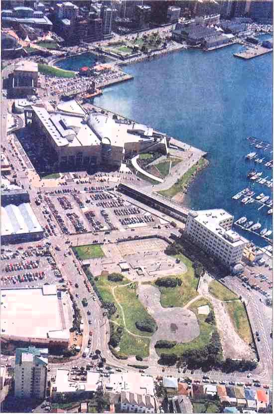
Will Rising Seas Ever Threaten Wellington's Waterfront?Telling the future by looking at the past assumes that conditions remain constant. This is like driving a car by looking in the rearview mirror. - Herb Brody The following picture was printed in the Evening Post on 19 January 2000 as part of an article on Lambton Harbour's plans for extensive building on the waterfront. We were first made aware of those plans weeks earlier at a meeting of Chaffers Marina shareholders. At that meeting, I asked David Gascoigne, Chairman of Lambton Harbour Management Limited, if the fact of rising sea levels had been factored into their building plans (as several of the proposed new buildings actually extended over the water on pilings). Presumably any new buildings would be expected to last at least 30-50 years, during which time the sea is projected to rise up to half a metre - possibly more if the Western Ice Sheet breaks loose (or other similar phenomena). Gascoigne seemed surprised at my question and said no, sea levels had not figured into their plans at all. Looking at the picture below, do you feel he is being short-sighted? (Our (former) boat, Lady Fair, is the one closest to the point of land in front of Te Papa.)
Geological Society of New Zealand Inc:
|
| By the End of the Century (two pages prior in this section) - Under the precautionary principle, the lack of full scientific certainty is no reason for postponing action to protect the environment. In other words, even if we don't have the facts, the government should take drastic measures as a first resort. This approach carries risks of its own... | |
| World's End (the previous page in this section) - Even if temperatures rise only moderately, some scientists fear the climate would reach a "tipping point" - a point at which even a tiny additional increase would throw the system into violent change... | |
| Poseidon Adventure - (the next page in this section) - Not everyone agrees on the speed with which global warming is causing the oceans to rise: "...the current sea level rate of rise after cycle 276 is 0.9 mm/yr, half the rate claimed for the last 100 years, and less than 1/5 the rate claimed for the 21st century..." |
![]()
Gaia Wearing Sunglasses?
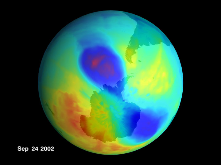
A Small Double Ozone Hole in 2002
Credit: SVS, TOMS, NASA
As expected, the ozone hole near Earth's South Pole is back again this year. This time, however, it's smaller than the past 2 years, and has an unusual double lobe structure. Ozone is important because it shields us from damaging ultraviolet sunlight. Ozone is vulnerable, though, to CFCs and halons being released into the atmosphere. International efforts to reduce the use of these damaging chemicals appear to be having a positive effect on their atmospheric abundance. The smaller size of the ozone hole this year, however, is attributed mostly to warmer than normal air in the surrounding stratosphere. The above picture of the ozone hole was taken on September 24 by TOMS on board the orbiting Earth Probe satellite.
Source: antwrp.gsfc.nasa.gov
![]()
For pages on several types of disasters - including lightning strikes, tornados, hurricanes, volcanoes, floods, global warming and more - as well as some great tree photos,
clicking the "Up" button immediately below takes you to the Table of Contents page for this Environment section.